G E O L O C 3 D
intended for
- Lost mine-holes or bore-holes discovering or their orientation
control during boring or mining processes.
- Seismic dangerous centers location and their state control
for earthquakes or mine-shocks prognosis.
includes
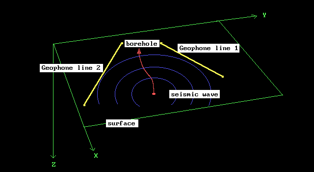
- Linear MEASUREMENTS seismic data by surface and subsurface
profiles. Wells and mine-holes are appropriated. The simple seismic sources,
or technology noise by exploding, mining or boring processes may be used
as the wave oscillation springs.
- Profiles data PROCESSING by the spectral wave-emission
tomography program TREC. Integral sections of the relative seismic emission
power in surrounding space will be obtained.
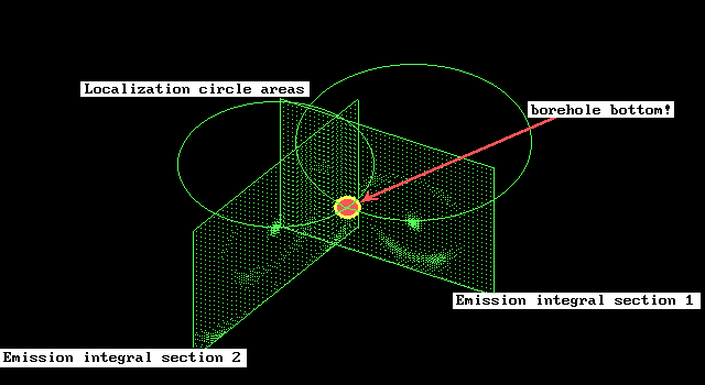
- Previous sections totality INTERPRETATION by the TLOC
program. Three-dimensional geospace localization of anomaly seismic emission
activity objects is implied.
- Result data REPRESENTATION through the virtual multi-dimensional
computer graphics program SpaceWork. Three-dimensional interpretation data
may be displayed on the screen or printing device with the additional geophysical
or technological information.
supported by
- TREC program - for the reverse seismic problems resolving
within wave approximation, in frequency domain. This allows to obtain two-dimensional
seismic sections through the human-made or native seismic oscillations.
Complex or absolute seismic wave diffraction or reflection factors, native
seismic emission power or phase characteristics may be represented on those
sections.
- TLOC program - for the three-dimensional diffraction-reflection
factors or emission power characteristics volumes. Anomaly vibration sources
may be localized in the bounds of obtained volumes.
- Powerful four-level plane and space virtual SpaceWork
computer graphics system. This program allows to represent line graphs,
data sections and volumes of many different physical fields simultaneously.
Common three-dimensional picture may be shown on the screen or printer
within defined point of view and scale.